During the middle years of the nineteenth century, the two most agriculturally productive counties in the United States were Lancaster, Pennsylvania, and Rockingham, Virginia. Although both were highly productive, the former significantly outperformed the latter. This raises two related questions: What was it about the agriculture of these two counties that made them so successful; and why was Lancaster able to outproduce every other county in the country?
Historically, Lancaster and Rockingham are very similar. Both were settled by backcountry pioneers; both counties were settled by German anabaptists, the Amish in Lancaster, and the Mennonites in Rockingham; and both regions practiced a similar grain and livestock mixed farming regime. However, a comparison of landuse patterns in either county presents an interesting contrast.
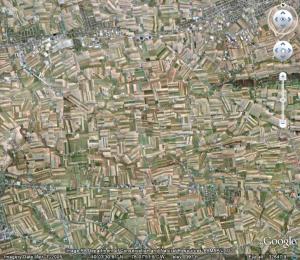
 This is an image of western Rockingham county. The field system is somewhat irregular, allowing for fields of varying size and shape; there is a significant area of forested land, occurring frequently along stream beds and hill tops; and the road and settlement patterns are loose, conforming to the topography, and following a dispersed town and country pattern. The image presents a complex landscape characterized by a combination of natural and artificial elements.
 This is an image of central Lacaster county. The field system is highly regular, with little variance in either size or shape; there is very little forested land, rather, every bit of land is under cultivation; and the road and settlement patterns are well organized, following a linear pattern through major corridors and a regularized hamlet pattern between. This is quite obviously a landscape maximized for agricultural productivity, and dominated by artificial elements.
In an examination of the landuse patterns of Lancaster and Rockingham counties, one may find answers to the questions asked above. Both counties dedicate a significant portion of their land to a similarly intensive pattern of agricultural use, and so were able to outproduce all others during the mid-nineteenth century. However, the intensity of regularity and organization found of Lancaster illustrates why farmers there were more productive even than those of Rockingham.
Thus, landuse patterns may be incredibly useful in learning about the nature of the world we inhabit, a world that is increasingly one of our own design. Whether attempting to answer questions of history or economy, psychology or ecology, the way in which people have interacted with the land may yield a rich array of information and insight. It is the purpose of the Global Landuse Pattern Survey to translate the story that has been inscribed on the surface of the Earth by generations of human beings, and to share it with all.
